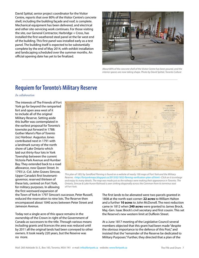
↗ View this article in the original PDF newsletter
Requiem for Toronto’s Military Reserve
In collaboration
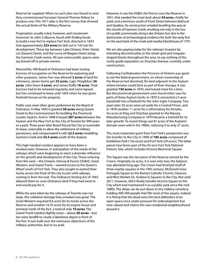
The interests of The Friends of Fort York go far beyond the ramparted fort and open area west of it to include all of the original Military Reserve. Setting aside this buffer was contemplated in the earliest proposal for Toronto’s townsite put forward in 1788: Gother Mann’s Plan of Torento (sic) Harbour. Augustus Jones contributed next in 1791 with a landmark survey of the north shore of Lake Ontario which laid out thirty-four lots in York Township between the current Victoria Park Avenue and Humber Bay. They extended back to a road allowance, now Queen Street. In 1793 Lt.-Col. John Graves Simcoe, This plan of 1852 by Sandford Fleming Upper Canada’s first lieutenantReserve. <http://fortyorkmaps.blogspot.ca/2013/02/1852-fleming-verification-plan-of.html> governor, reserved thirteen of and enjoy its many details. The map these lots, centred on Fort York, Ontario, Simcoe & Lake Huron Railroad of Fort York. for military purposes. In allowing the first westward expansion of the Town of York in 1797 Simcoe’s successor, Peter Russell, reduced the reservation to nine lots. The Reserve then encompassed about 1040 acres between Peter Street and Jameson Avenue.
Today not a single acre of this space remains in the ownership of the Crown in right of the Government of Canada as successors to the title. Through various means including grants and licences the area was reduced until by 2011 all the original lands had been conveyed to other owners. It took nearly 220 years, but the Reserve was no more. Mail: 260 Adelaide St. E., Box 183, Toronto, M5A 1N1 e-mail: info@fortyork.ca
is found on a website of nearly 100 maps of Fort York and the Military Click on it to enlarge was made just as the railways were making their appearance in Toronto. The is seen striking diagonally across the Common from its terminus east The first lands to be alienated were two parcels granted in 1808 at the north-east corner: 22 acres to William Halton and a further 10 acres to John McDonell. The next reduction came in 1812 when 240 acres were granted to James Brock, Maj.-Gen. Isaac Brock’s civil secretary and first cousin. This set the Reserve’s new western limit at Dufferin Street. At a June 1817 meeting of the Legislative Council several members objected that this grant had been made “despite the obvious importance to the defence of this Post,” and insisted that the “remainder of the Reserve be dedicated to Military Purposes.” Further, they directed that a plan of the website: www.fortyork.ca The Fife and Drum 7
Reserve be supplied. When no such plan was found to exist they commissioned Surveyor General Thomas Ridout to produce one. This 1817 plan is the first survey that showed the actual limits of the Military Reserve. Pragmatism usually ruled, however, and LieutenantGovernor Sir John Colborne, faced with finding funds to build a new fort to replace Fort York, directed in 1833 that approximately 223 acres be laid out in 142 lots for development. These lay between Lake Ontario, Peter Street, Lot [Queen] Street, and the curve of Niagara Street along the Garrison Creek ravine. All save some public spaces were auctioned off to private owners. Meanwhile, HM Board of Ordnance had been issuing licences of occupation on the Reserve for pasturing and other purposes. James Farr was allowed 2 acres of land for a brewery, James Givins got 23 acres, Capt. Fitzgibbon 26 acres, John Dunn 5 acres, and James Duffy 18 acres. Their licences had to be renewed regularly, and some lapsed, but Farr continued to lease until 1854 when he was given freehold tenure on his property. Public uses were often given preference by the Board of Ordnance. In May 1845 it granted 50 acres along Queen Street to the Commissioners for building the Provincial Lunatic Asylum. And in 1848 it leased 287 acres between the Asylum and the New Fort to the City of Toronto for 999 years as a park. Three years later Board forced the City to surrender its lease, ostensibly to allow the settlement of military pensioners, and compensated it with 22.5 acres straddling Garrison Creek and 33.5 acres south of the Asylum. This high-handed conduct appears to have been a smokescreen, however, in anticipation of the needs of the railways which were beginning to exert a dramatic influence on the growth and development of the City. Those entering from the west—the Ontario, Simcoe & Huron (OS&H), Great Western, and Grand Trunk—wanted access to the Queen’s Wharf south of Fort York. They also sought to extend their tracks across the front of the city to join with railways coming in from the east. The Ordnance Vesting Act of 1843 allowed them to cross Ordnance land if they had need to and would pay for it. While the area taken by the railways at Toronto was not large, the collateral damage they wreaked was great. The Great Western required 8.6 acres for its tracks across the Reserve and another 10.35 acres for its engine house and terminal north of the fort, a total of only 19 acres. The Grand Trunk needed slightly more—about 20 acres—but ten were landfill to create a lakeshore depot in front of the fort. It was built over the strenuous objections of the military authorities, but to no avail. 8 The Fife and Drum
However, it was the OS&H, the first to cross the Reserve in 1851, that needed the most land, about 34 acres, chiefly for yards and a terminus south of Front Street between Bathurst and Spadina. Its construction entailed levelling the area at the mouth of Garrison Creek, resulting not only in the loss of a public promenade along Lake Ontario but also in the destruction of archaeological evidence for both the early fort on the east bank of the creek and nearby blockhouse of 1797. We are also paying today for the railways’ invasion by tolerating discontinuities in the street-grid and irregularshaped blocks throughout the area, to say nothing of the costly grade separation on Strachan Avenue currently under construction. Following Confederation the Province of Ontario was quick to ask the federal government, on whom ownership of the Reserve had devolved, for land adjacent to the Asylum where inmates could farm as part of their therapy. It was granted 150 acres in 1870, and leased more for a time. But the provincial government soon found other uses for parts of these Asylum lands. In 1870 it converted a 5-acre leasehold into a freehold for the John Inglis Company. Two years later 20 acres were set aside for a Central Prison, and in 1878 another 11 acres for a reformatory for females. Six acres at King and Strachan granted to the Massey Manufacturing Company in 1879 became a toehold for its later growth. To round things out 81 acres of the Asylum’s domain were sold in the 1880s, reducing it to only 27 acres. The most important grant from Fort York’s perspective was the transfer to the City in 1909 of 185 acres composed of Exhibition Park (156 acres) and Fort York (29 acres). The latter parcel now forms part of the 43-acre Fort York National Historic Site, which includes Victoria Memorial Square. The Square was the last piece of the Reserve owned by the Crown. Originally six acres, it is now only two; the balance was alienated long ago. The Crown had divested itself of three nearby squares in the 19th century: McDonell [now Portugal] Square to the Roman Catholic Church; Clarence and West Market [St. Andrew’s] Squares to the City. Not until 2011, however, did it finally transfer Victoria Square to the City which had maintained it as a public park since the mid1880s. The delay can be put down to the military cemetery holding 400-500 people that fills most of the square. Indeed, it is fitting that the dead were the best defenders of an open space once under pressure for redevelopment but now valued and vital to the new residential neighbourhood around it.
Original printed pages