↗ View this article in the original PDF newsletter
Construction of the new Visitor Centre has attracted much public attention in the last two years but another major transformation is about to take place at the fort. Within the next short while the Garrison Road Bridge will be removed.
Fort York now has a prominent street presence and a new entrance road from Fort York Boulevard, but for a generation, finding a way into the fort was confusing. Access was via the nearly hidden Garrison Road and then across an unexpected elevated bridge under the towering Gardiner Expressway. The need for the Garrison Road Bridge was not immediately apparent but it was built to cross the former rail bed of the Canadian Pacific (Grand Trunk) Railway. Known as the Queen’s Wharf Lead, the old single track led from the west side of Strachan Avenue in a deep cut. West of Bathurst Street this important lead served Molson Breweries and the Canada Cement Company. The track ran east underneath Bathurst Street Bridge serving, among others, the Loblaws warehouse, the Canada Malting elevators, Maple Leaf Mills, and the Terminal Warehouse (Queens Quay Terminal). The lead, which once ran all across the waterfront, was shortened from time to time until finally it ended at Bathurst Street; the tracks were not removed until 1990. Now the land is owned by the City of Toronto.
1854-5
When the major new railways entered Toronto from the west and north in the early 1850s, it was necessary for them to cross military lands to reach their destinations on the waterfront. One company, the Grand Trunk Railway (GTR), not only crossed military lands but extended its tracks along the south side of Fort York and constructed an engine house southeast of the fort. In order for tracks to descend from the level of the military common to the level of the lake, a long, deep cut was required southwest of the fort. This excavation, up to 20 feet in depth and about 1200 feet in length, extended from west of present Strachan Avenue to the edge of the lake, at that time just south of the new Visitor Centre. This cut provided the material necessary to fill the lake in front of the fort for the new tracks and engine house. All of the work was completed by the GTR despite a vigorous and sustained opposition by the military. Significantly, the excavation for new tracks southwest of the fort cut the road that was considered indispensable for the defence of the City and made traffic between the Old Fort and the New Fort impossible. The digging of the railway cut essentially isolated Fort York and the adjoining Common Ground from the rest of the Military Reserve to the southwest.
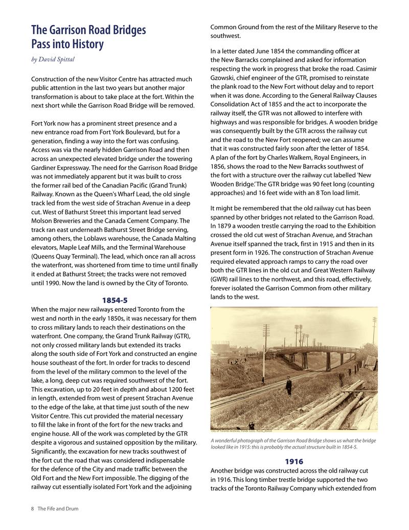
In a letter dated June 1854 the commanding officer at the New Barracks complained and asked for information respecting the work in progress that broke the road. Casimir Gzowski, chief engineer of the GTR, promised to reinstate the plank road to the New Fort without delay and to report when it was done. According to the General Railway Clauses Consolidation Act of 1855 and the act to incorporate the railway itself, the GTR was not allowed to interfere with highways and was responsible for bridges. A wooden bridge was consequently built by the GTR across the railway cut and the road to the New Fort reopened; we can assume that it was constructed fairly soon after the letter of 1854. A plan of the fort by Charles Walkem, Royal Engineers, in 1856, shows the road to the New Barracks southwest of the fort with a structure over the railway cut labelled ‘New Wooden Bridge.’ The GTR bridge was 90 feet long (counting approaches) and 16 feet wide with an 8 Ton load limit.
It might be remembered that the old railway cut has been spanned by other bridges not related to the Garrison Road. In 1879 a wooden trestle carrying the road to the Exhibition crossed the old cut west of Strachan Avenue, and Strachan Avenue itself spanned the track, first in 1915 and then in its present form in 1926. The construction of Strachan Avenue required elevated approach ramps to carry the road over both the GTR lines in the old cut and Great Western Railway (GWR) rail lines to the northwest, and this road, effectively, forever isolated the Garrison Common from other military lands to the west.
A wonderful photograph of the Garrison Road Bridge shows us what the bridge looked like in 1915: this is probably the actual structure built in 1854-5.
1916
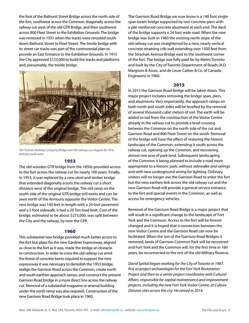
Another bridge was constructed across the old railway cut in 1916. This long timber trestle bridge supported the two tracks of the Toronto Railway Company which extended from the foot of the Bathurst Street Bridge across the north side of the fort, southwest across the Common, diagonally across the railway cut west of the old GTR Bridge, and then southwest across 800 Fleet Street to the Exhibition Grounds. The bridge was removed in 1931 when the tracks were rerouted south down Bathurst Street to Fleet Street. The trestle bridge with its street car tracks was part of the controversial plan to provide an East Entrance to the Exhibition Grounds. In 1915 the City approved $123,000 to build the tracks and platforms and, presumably, the trestle bridge.
1953
The old wooden GTR bridge from the 1850s provided access to the fort across the railway cut for nearly 100 years. Finally, in 1953, it was replaced by a new steel and timber bridge that extended diagonally across the railway cut a short distance west of the original bridge. The old ramp on the south side of the original GTR bridge still exists and can be seen north of the Armoury opposite the Visitor Centre. The new bridge was 140 feet in length with a 24 foot pavement and a 5 foot sidewalk; it had a 20 Ton load limit. Cost of the bridge, estimated to be about $273,000, was split between the City and the railway, by now the CPR.
1960
This substantial new bridge provided much better access to the fort but plans for the new Gardiner Expressway, aligned as close to the fort as it was, made the bridge an obstacle to construction. In order to cross the old railway cut amid the forest of concrete bents required to support the new expressway it was necessary to demolish the 1953 bridge, realign the Garrison Road across the Common, create north and south earthen approach ramps, and construct the present Garrison Road Bridge in a more direct line across the railway cut. Removal of a substantial magazine or arsenal building under the north ramp was also required. Construction of the new Garrison Road Bridge took place in 1960.
The Garrison Road Bridge we now know is a 148 foot single span beam bridge supported by two concrete piers with a pile reinforced concrete abutment at each end. The deck of the bridge supports a 24 foot wide road. When the new bridge was built in 1960 the existing north slope of the old railway cut was straightened by a new, nearly vertical concrete retaining crib wall extending over 1500 feet from the Strachan Avenue Bridge east to the southwest corner of the fort. The bridge was fully paid for by Metro Toronto and built by the City of Toronto Department of Roads (A.D. Margison & Assoc. and de Leuw Cather & Co. of Canada, Engineers) in 1960.
2015
In 2015 the Garrison Road Bridge will be taken down. This major project includes removing the bridge span, piers, and abutments. Very importantly, the approach ramps on both north and south sides will be levelled by the removal of several thousand cubic meters of soil. The earth will be added to soil from the construction of the Visitor Centre already in the railway cut to provide a level crossing between the Common on the north side of the cut and Garrison Road and 800 Fleet Street on the south. Removal of the bridge will have the effect of restoring the historic landscape of the Common, extending it south across the railway cut, opening up the Common, and recovering almost one acre of park land. Subsequent landscaping of the Common is being planned to include a road more appropriate to a historic park, without sidewalks and railings and with new underground wiring for lighting. Ordinary visitors will no longer use the Garrison Road to enter the fort but the new earthen link across the old railway cut and the new Garrison Road will provide a general service entrance to the fort and special events in the Common, as well as access for emergency vehicles.
Removal of the Garrison Road Bridge is a major project that will result in a significant change to the landscape of Fort York and the Common. Access to the fort will be forever changed and it is hoped that a connection between the new Visitor Centre and the Garrison Road can now be facilitated. When the last of the Garrison Road Bridges is removed, lands of Garrison Common Park will be recovered and Fort York and the Common will, for the first time in 160 years, be reconnected to the rest of the old Military Reserve.
Original printed pages