↗ View this article in the original PDF newsletter
The Bentway is proposing a heavy cycling and pedestrian bridge over Fort York Boulevard that would land only metres from the fort’s southern rampart, occupying a large part of the original shoreline and blocking north/south views of the fort. Although given conditional approval by the design review panel advising Waterfront Toronto – which paid little attention to the heritage aspects of the site – the proposal raised serious concerns for a volunteer committee that provides advice to The Friends of Fort York & Garrison Common.
The Precinct Advisory Committee (PAC) of The Friends was briefed in June by Melanie Morris of Waterfront Toronto, which is managing the project, and its designer, Marc Ryan of Public Work. Their aim is to complete documentation of the project by the autumn in order to begin seeking funding. Construction, however, cannot begin until remediation of that portion of the Gardiner Expressway is complete, estimated to be about five years away.
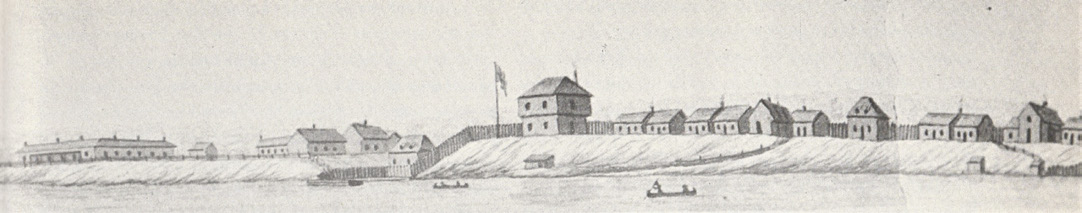
The PAC’s main objection is to the occupation, by the bridge’s massive north landing, of much of the open space immediately below the fort’s south rampart. That open space reflects the original shoreline of Lake Ontario and explains why the fort was built where it was. It’s a crucial feature of the city’s “founding landscape” – considered the topography of the fort, the lower reaches of Garrison Creek and the plain of Garrison Common – that was carefully preserved by locating the boulevard as far away from the ramparts as it is. The north-south streets of the Fort York neighbourhood (Gzowski, Bastion, Grand Magazine and Iannuzzi, along with June Callwood Park) were themselves intentionally aligned with the Gardiner’s bents to preserve views of the National Historic Site from the south as well as views toward the lake from the fort’s ramparts.
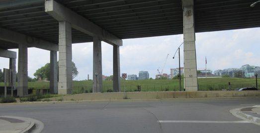
Although an initial Environmental Assessment was done, its terms were tightly limited: how to safely cross Fort York Blvd at that location – that is, at the bottom of a curving slope. Only two options there are safe: a tunnel (not realistic) or a bridge. There is, meanwhile, a new traffic light for safely crossing Fort York Blvd at June Callwood Park, a two-minute walk to the west. Here, the road is straight and flat.
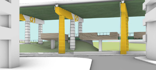
Ryan was given a difficult problem. His original design was of a bridge suspended from beneath the Gardiner, a light structure that did not require the heavy columns, steel beams and bulky earthworks of the revision. That unobtrusive flying design was nixed by the City’s powerful roads department, which argued that the Gardiner was not engineered for that kind of additional load and that maintenance of the highway would be impeded.
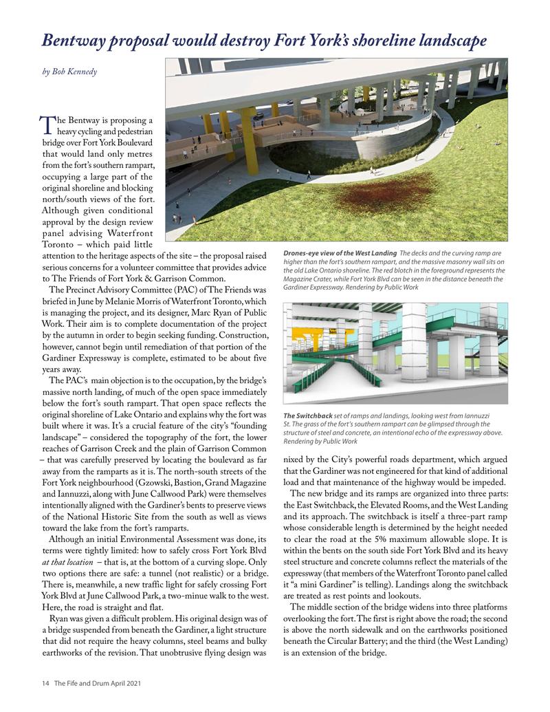
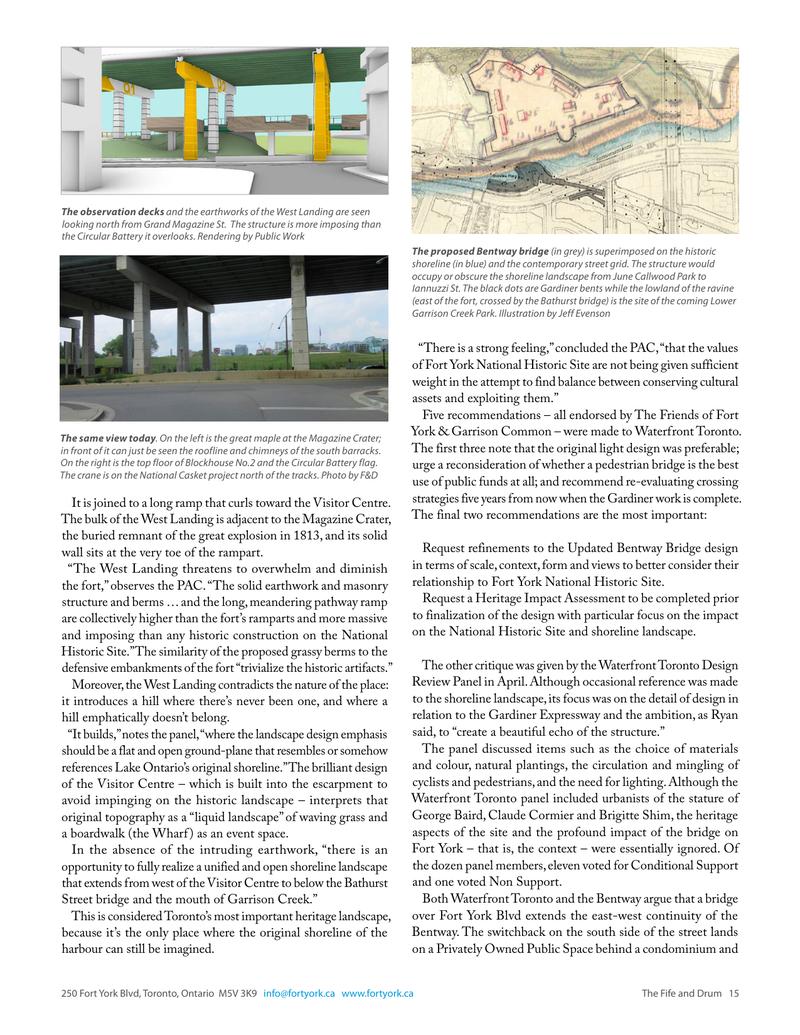
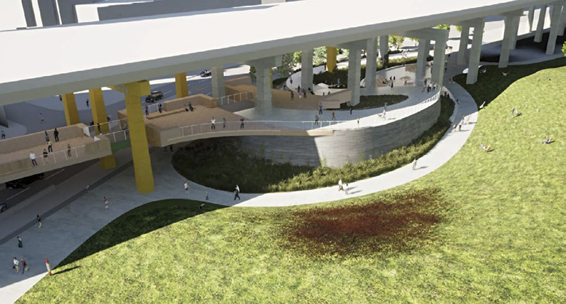
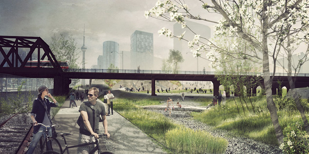
The new bridge and its ramps are organized into three parts: the East Switchback, the Elevated Rooms, and the West Landing and its approach. The switchback is itself a three-part ramp whose considerable length is determined by the height needed to clear the road at the 5% maximum allowable slope. It is within the bents on the south side Fort York Blvd and its heavy steel structure and concrete columns reflect the materials of the expressway (that members of the Waterfront Toronto panel called it “a mini Gardiner” is telling). Landings along the switchback are treated as rest points and lookouts.
The middle section of the bridge widens into three platforms overlooking the fort. The first is right above the road; the second is above the north sidewalk and on the earthworks positioned beneath the Circular Battery; and the third (the West Landing) is an extension of the bridge.
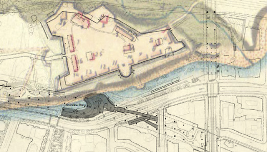
It is joined to a long ramp that curls toward the Visitor Centre. The bulk of the West Landing is adjacent to the Magazine Crater, the buried remnant of the great explosion in 1813, and its solid wall sits at the very toe of the rampart.
The West Landing threatens to overwhelm and diminish the fort.
“The West Landing threatens to overwhelm and diminish the fort,” observes the PAC. “The solid earthwork and masonry structure and berms … and the long, meandering pathway ramp are collectively higher than the fort’s ramparts and more massive and imposing than any historic construction on the National Historic Site.” The similarity of the proposed grassy berms to the defensive embankments of the fort “trivialize the historic artifacts.”
Moreover, the West Landing contradicts the nature of the place: it introduces a hill where there’s never been one, and where a hill emphatically doesn’t belong.
“It builds,” notes the panel, “where the landscape design emphasis should be a flat and open ground-plane that resembles or somehow references Lake Ontario’s original shoreline.” The brilliant design of the Visitor Centre – which is built into the escarpment to avoid impinging on the historic landscape – interprets that original topography as a “liquid landscape” of waving grass and a boardwalk (the Wharf) as an event space.
In the absence of the intruding earthwork, “there is an opportunity to fully realize a unified and open shoreline landscape that extends from west of the Visitor Centre to and over the Bathurst Street bridge and the mouth of Garrison Creek.”
This is considered Toronto’s most important heritage landscape, because it’s the only place where the original shoreline of the harbour can still be imagined.
“There is a strong feeling,” concluded the PAC, “that the values of Fort York National Historic Site are not being given sufficient weight in the attempt to find balance between conserving cultural assets and exploiting them.”
Five recommendations – all endorsed by The Friends of Fort York & Garrison Common – were made to Waterfront Toronto. The first three note that the original light design was preferable; urge a reconsideration of whether a pedestrian bridge is the best use of public funds at all; and recommend re-evaluating crossing strategies five years from now when the Gardiner work is complete. The final two recommendations are the most important:
Request refinements to the Updated Bentway Bridge design in terms of scale, context, form and views to better consider their relationship to Fort York National Historic Site.
Request a Heritage Impact Assessment to be completed prior to finalization of the design with particular focus on the impact on the National Historic Site and shoreline landscape.
The other critique was given by the Waterfront Toronto Design Review Panel in April. Although occasional reference was made to the shoreline landscape, its focus was on the detail of design in relation to the Gardiner Expressway and the ambition, as Ryan said, to “create a beautiful echo of the structure.”
The panel discussed items such as the choice of materials and colour, natural plantings, the circulation and mingling of cyclists and pedestrians, and the need for lighting. Although the Waterfront Toronto panel included urbanists of the stature of George Baird, Claude Cormier and Brigitte Shim, the heritage aspects of the site and the profound impact of the bridge on Fort York – that is, the context – were essentially ignored. Of the dozen panel members, eleven voted for Conditional Support and one voted Non Support.
Both Waterfront Toronto and the Bentway argue that a bridge over Fort York Blvd extends the east-west continuity of the Bentway. The switchback on the south side of the street lands on a Privately Owned Public Space behind a condominium and leads, across Iannuzzi Street, to another – both of them now largely deserted hardscapes and very much in need of animation. This is the need and the opportunity seen by the programmers of the Bentway.
But the east-west continuity of movement under the Gardiner comes to a dead halt only 80 metres from the Switchback, at the dangerous obstacle of Bathurst Street. Here it’s four lanes of traffic with two streetcar tracks wide (broadening to six lanes a few metres south) presenting pedestrians with three choices: walk north, uphill, and safely cross at Fort York Blvd; walk a block south to the risible intersection of Bathurst and Lake Shore, one of the most unfriendly to pedestrians in all of downtown; or risk dashing straight across the street, which – given the new LCBO, Loblaws and Shoppers Drug Mart on the far side – is what people are doing all day long.
Under the Gardiner on the east side of Bathurst, what might have been a striking plaza behind the new towers is being used as surface parking for the LCBO. Further east, the space under the Gardiner beneath and around the infamous POPs created with the enveloping “Mitosis Courtyard,” an area artwork by Pierre Poussin commissioned by Concord, has, the developers in 2010. Concord recently announced plans to fully redevelop the space behind the Panorama condominium with four two-storey retail buildings on the historic facade. “The space is not seen as a destination,” argues Concord. But it will be, and there’s a better way to get here. It’s from the north.
A more congenial route than this dangerous dash across Bathurst under the Gardiner is already planned: trails under the Bathurst bridge through Sir Isaac Brock Park and southeast below the fort to the projected Lower Garrison Creek Park. Also designed by Marc Ryan – with an entirely different aesthetic – it embodies the important shoreline landscape and leads, around the library on a short way down Dan Leckie Way, to Canoe Landing and its built-in bicycle route south.
At the foot of Douglas Coupland’s park, under the Gardiner and across Dan Leckie Way, is where Concord’s plans to animate the space. At this point we’re in clear sight of the harbour and the Waterfront Trail, and the crossing of Lake Shore Blvd here actually feels safe. The short, wide stretch of Dan Leckie Way that links to Queens Quay is itself ripe for an aesthetic upgrade.
The Gardiner runs from here along the south bank of the park, creating an empty and continuous vaulted space all the way to Spadina – exactly the sort of orphan linear space the Bentway was created to solve and exploit.
The irony of the Bentway’s heavy bridge proposal is that it would largely destroy the very landscape it purports to celebrate. And it overwhelms Toronto’s most important historic site by erecting huge platforms to peer into it. It’s a vivid illustration of a problem common to all science: the disturbance of a system by the very act of observing it. Scientists, however, always strive to minimize the disturbance, knowing that failing to do so is likely to undermine the very point of their work.
The members of the Precinct Advisory Committee of The Friends of Fort York & Garrison Common include Pamela Robinson, director of the School of Urban and Urban Planning at Ryerson; Lisa Raeken, former architecture critic of The Globe and Mail; Robert Allsopp, Partner Emeritus at DTAH (the original developers of the Fort York National Historic Site plan); Melanie Hare, Partner at Urban Strategies; and Rick Merrill, Senior Advisor at The Planning Partnership. Waterfront Toronto VP Partnerships & Strategy at Options For Homes. Bob Kennedy is the Editor of the F&D and lives just down the street from the fort.
Original printed pages