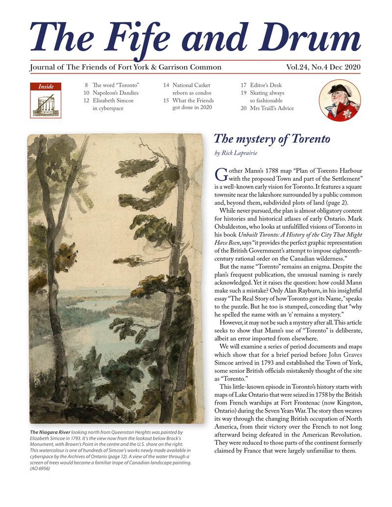
↗ View this article in the original PDF newsletter
Gother Mann’s 1788 map “Plan of Torento Harbour with the proposed Town and part of the Settlement” is a well-known early vision for Toronto. It features a square townsite near the lakeshore surrounded by a public common and, beyond them, subdivided plots of land (page 2). While never pursued, the plan is almost obligatory content for histories and historical atlases of early Ontario. Mark Osbaldeston, who looks at unfulfilled visions of Toronto in his book Unbuilt Toronto: A History of the City That Might Have Been, says “it provides the perfect graphic representation of the British Government’s attempt to impose eighteenth-century rational order on the Canadian wilderness.”
But the name “Torento” remains an enigma. Despite the plan’s frequent publication, the unusual naming is rarely acknowledged. Yet it raises the question: how could Mann make such a mistake? Only Alan Rayburn, in his insightful essay “The Real Story of how Toronto got its Name,” speaks to the puzzle. But he too is stumped, conceding that “why he spelled the name with an ‘e’ remains a mystery.”
However, it may not be such a mystery after all. This article seeks to show that Mann’s use of “Torento” is deliberate, albeit an error imported from elsewhere.
We will examine a series of period documents and maps which show that for a brief period before John Graves Simcoe arrived in 1793 and established the Town of York, some senior British officials mistakenly thought of the site as “Torento.”
This little-known episode in Toronto’s history starts with maps of Lake Ontario that were seized in 1758 by the British from French warships at Fort Frontenac (now Kingston, Ontario) during the Seven Years War. The story then weaves its way through the changing British occupation of North America, from their victory over the French to not long afterward being defeated in the American Revolution. They were reduced to those parts of the continent formerly claimed by France that were largely unfamiliar to them.
The Laforce Map of Lake Ontario
Thirty years before Mann drew his plan, the British acquired two French manuscript maps of Lake Ontario. Neither of them uses the name Torento.
In August 1758, when the British attacked Fort Frontenac, two French naval vessels sought to sail out of the Cataraqui River into open water. Hampered by unfavourable winds, they were fired upon and hulled by British cannon. Both ships ran aground below the fort and were abandoned by captains and crews, who disappeared into the nearby woods. Fort Frontenac, its stores and the entire French fleet on Lake Ontario fell into British hands. One and possibly both maps were seized that day from the beached French vessels.
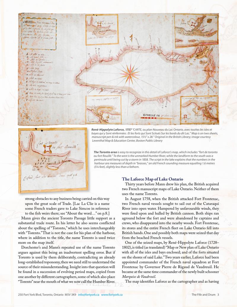
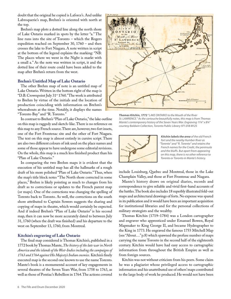
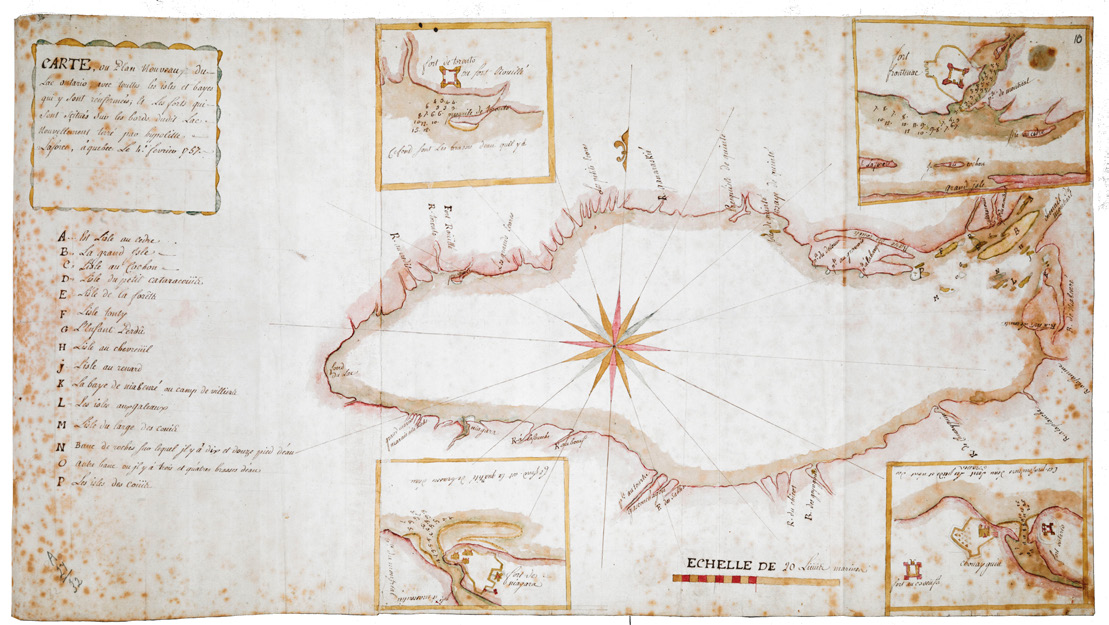
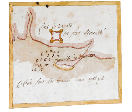
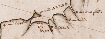
One of the seized maps, by René-Hippolyte Laforce (1728–1802), is titled (as translated) “Map or New plan of Lake Ontario with all of the isles and bays enclosed; and of the forts situated on the shores of said Lake.” Two years earlier, Laforce had been appointed commander of the French naval squadron at Fort Frontenac by Governor Pierre de Rigaud de Vaudreuil. He became at the same time commander of the newly built schooner Marquise de Vaudreuil.
The map identifies Laforce as the cartographer and as having been made at Quebec, February 4, 1757. There are four insets: the French forts of Toronto, Niagara and Frontenac and the English Fort Ontario at Oswego. Part of his detail of tactical locations and depth soundings. On the main part of the map is an alphabetically arranged legend listing 15 place names corresponding to sites at the eastern end of Lake Ontario.
Although commonly known and mapped as Fort Toronto, the name “Fort Rouillé” (on both the map and in the notes) was the official designation of what was administratively an outpost of Niagara. It was named after Antoine Louis Rouillé, the Secretary of State for the Navy under King Louis XV. This is one of only a few maps to properly include the name Rouillé.
The Labroquerie Map of Lake Ontario
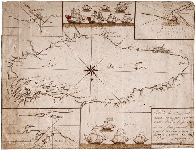
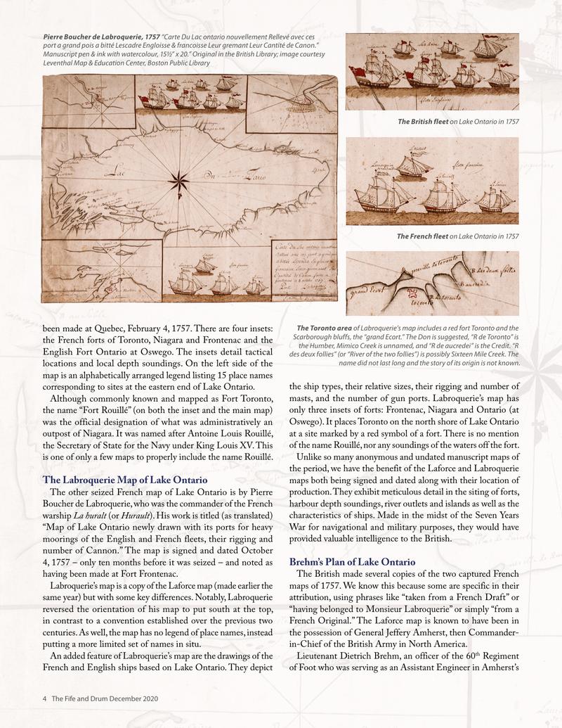
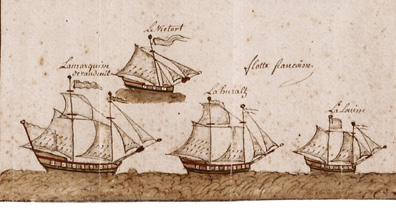
The other seized French map of Lake Ontario is by Pierre Boucher de Labroquerie, who was the commander of the French warship La huralt (or Hurault). His work is titled (as translated) “Map of Lake Ontario newly drawn with its ports for heavy moorings of the English and French fleets, their rigging and number of Cannon.” The map is signed and dated October 4, 1757 – only ten months before it was seized – and noted as having been made at Fort Frontenac.
Labroquerie’s map is a copy of the Laforce map (made earlier the same year) but with some key differences. Notably, Labroquerie reversed the orientation of his map to put south at the top, in contrast to a convention established over the previous two centuries. As well, the map has no legend of place names, instead putting a more limited set of names in situ.
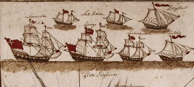
An added feature of Labroquerie’s map are the drawings of the French and English ships based on Lake Ontario. They depict the ship types, their relative sizes, their rigging and number of masts, and the number of gun ports. Labroquerie’s map has only three insets of forts: Frontenac, Niagara and Ontario (at Oswego). It places Toronto on the north shore of Lake Ontario at a site marked by a red symbol of a fort. There is no mention of the name Rouillé, nor any soundings of the waters off the fort.
Unlike so many anonymous and undated manuscript maps of the period, we have the benefit of the Laforce and Labroquerie maps both being signed and dated along with their location of production. They exhibit meticulous detail in the siting of forts, harbour depth soundings, river outlets and islands as well as the characteristics of ships. Made in the midst of the Seven Years War for navigational and military purposes, they would have provided valuable intelligence to the British.
Brehm’s Plan of Lake Ontario
The British made several copies of the two captured French maps in 1757. We know this because some are specific in their attribution, using phrases like “taken from a French Draft” or “having belonged to Monsieur Labroquerie” or simply “from a French Original.” The Laforce map is known to have been in the possession of General Jeffery Amherst, then Commander-in-Chief of the British Army in North America.
Lieutenant Dietrich Brehm, an officer of the 60th Regiment of Foot who was serving as an Assistant Engineer in Amherst’s army, made at least two copies of the French maps. Both were drawn in 1760, when Amherst was building Fort Crown Point on Lake Champlain in preparation for the final advance north to Montreal. Together with British armies advancing down the St. Lawrence from Oswego, and up the river from Quebec, this convergence on the unfortified city completed the conquest of New France. Brehm is known to have been at Crown Point until early in September 1760.

Just after the capitulation of Montreal on September 8, he was ordered to join the expedition to the west being assembled by Major Robert Rogers. The famous commander of the Rangers was being sent to assume control of the French posts in the interior, and Brehm’s assignment was to map and sketch their route. He travelled extensively in the lower Great Lakes and surrounding area and saw more of the territory in the two years he spent there than any other cartographer before him, French or English.
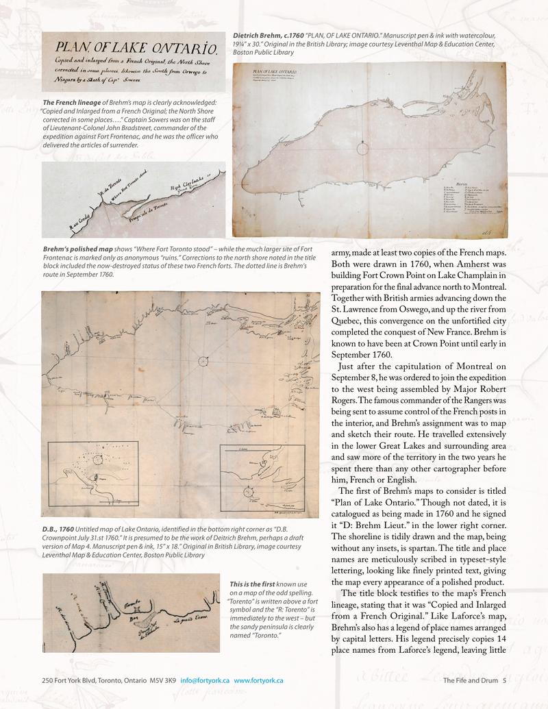
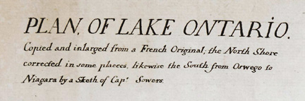
The first of Brehm’s maps to consider is titled “Plan of Lake Ontario.” Though not dated, it is catalogued as being made in 1760 and he signed it “D: Brehm Lieut.” in the lower right corner. The shoreline is tidily drawn and the map, being without any insets, is spartan. The title and place names are meticulously scribed in typeset-style lettering, looking like finely printed text, giving the map every appearance of a polished product.
The title block testifies to the map’s French lineage, stating that it was “Copied and inlarged from a French Original.” Like Laforce’s map, Brehm’s also has a legend of place names arranged by capital letters. His legend precisely copies 14 place names from Laforce’s legend, leaving little doubt that the original he copied is Laforce’s. And unlike Labroquerie’s map, Brehm’s 1772 history, rich oriented with north at the top.
Brehm’s map plots a dotted line along the north shore of Lake Ontario marked in spots by the letter “a.” The line runs into the site of Toronto – which the label on the map says the expedition reached on September 30, 1760 – and then crosses the lake to Fort Niagara. A note written in script at the bottom of the shoreline explains the marking: “NB: The places where we went in the Night is markt with a small a.” As the note was written in script, it and the dotted line of their route could have been added to the
Original printed pages